Make your way around the Everglades with this in-depth map

Spanning more than 1.5 million acres of wetlands, the Everglades is vast, wild, and increasingly complex. Whether you're planning a scenic airboat tour, a backcountry hike, or a peaceful canoe ride, this Everglades map will help you find your way. Discover the top parks, visitor centers, nature trails, and more to make the most of your visit.

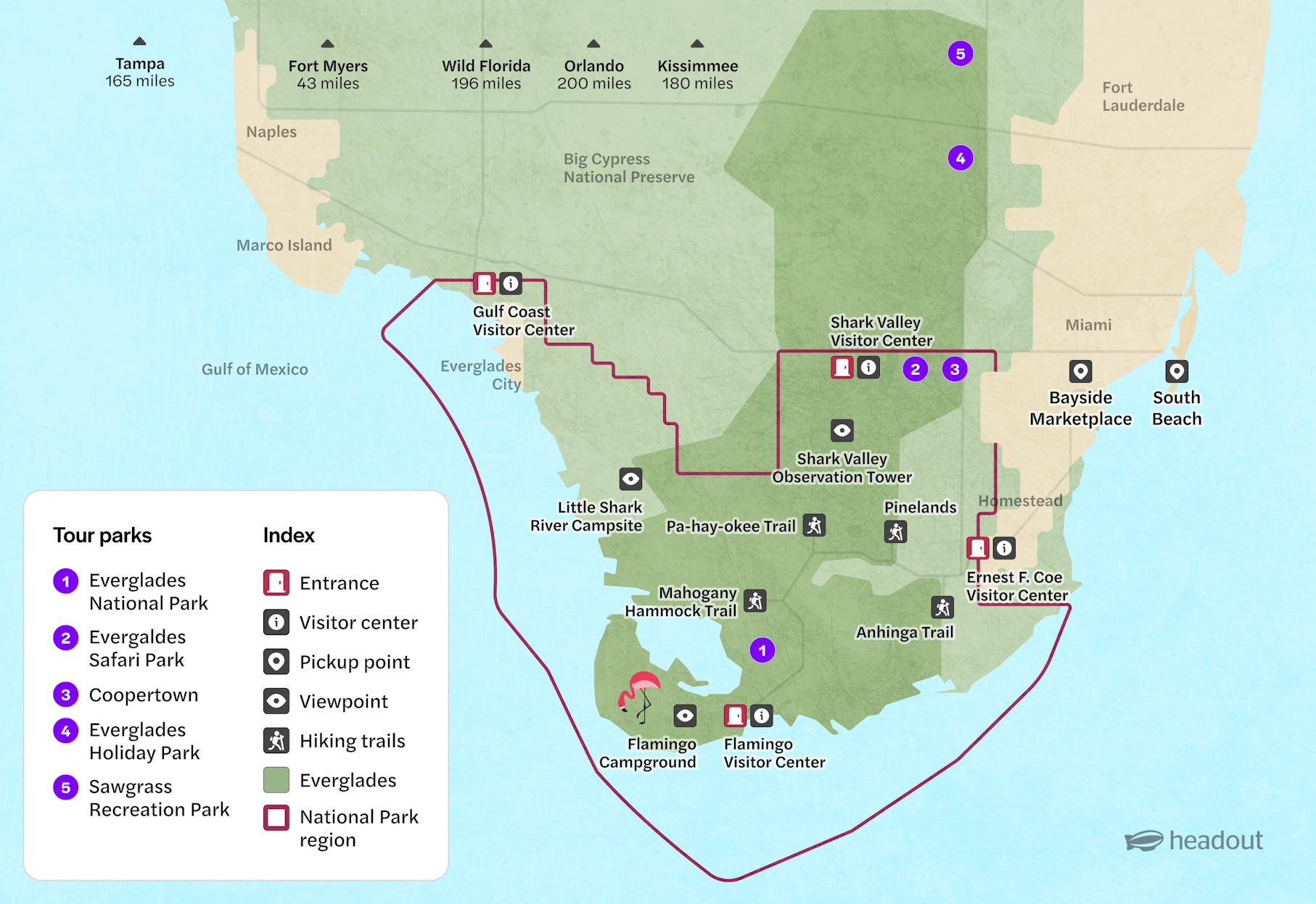
Map of the Everglades

Use this map to locate major visitor hubs like Ernest F. Coe Visitor Center, Shark Valley, and Flamingo, along with the locations of top airboat tour operators like Everglades Safari Park, Coopertown, and Holiday Park. Key hiking trails, wildlife viewing spots, and campgrounds are also marked to help you plan a seamless adventure.

Map of Everglades National Park showing visitor centers, trails, and tour parks.

Navigating the Everglades

Getting around the Everglades can feel overwhelming, especially on your first visit. Here's a quick guide to navigating the key zones within the park and nearby airboat tour sites:

  • Everglades National Park (1): The heart of the region, covering a diverse range of ecosystems. Main entrances are at Ernest F. Coe Visitor Center and Gulf Coast Visitor Center.
  • Everglades Safari Park (2): One of the most popular airboat tour operators, located on the Tamiami Trail near Shark Valley.
  • Coopertown Airboat Tours (3): A rustic, family-owned operation offering classic Everglades experiences.
  • Everglades Holiday Park (4): Located northwest of the main park in Fort Lauderdale, ideal for those based near the city.
  • Sawgrass Recreation Park (5): A family-friendly park with airboat tours, animal exhibits, and easy access from Fort Lauderdale and Miami.

Visitor facilities

  • Entrances & Visitor Centers: There are three main access points and visitor centers including Ernest F. Coe Visitor Center, Shark Valley Visitor Center, & Gulf Coast Visitor Center.
  • Restrooms: Available at all visitor centers, Flamingo Campground, and airboat tour offices like Safari Park and Coopertown.
  • Parking: Free parking is available at most visitor centers and trailheads. Expect paid parking at some private tour operators.
  • Dining options: Flamingo has a food truck and marina store. Limited snacks and beverages are available at most visitor centers and airboat tour offices.
  • Water refilling stations: Found at Shark Valley and Ernest F. Coe Visitor Centers.
  • Wheelchair/stroller accessibility: Shark Valley’s observation tower path is wheelchair-friendly. Accessible parking and facilities are provided at major visitor centers.
  • Campgrounds: There are two main campgrounds. The Flamingo Campground near Flamingo Visitor Center is open year-round and the Little Shark River Campsite which is more remote, suited for experienced backcountry campers.

Must-see highlights

Shark Valley Observation Tower in Everglades National Park with walkway and lush greenery.

Shark Valley Observation Tower

Offers panoramic views of the Everglades from a 45-foot high tower, great for spotting gators, birds, and sunsets.

Guests exploring boardwalk in Everglades wildlife park.
Person walking on Mahogany Hammock Trail boardwalk in Everglades National Park.
Boardwalk through lush mangroves at Pa-hay-okee Overlook, Everglades.
Flamingos wading in the Everglades wetland area.

Tips for your visit 

  • Plan your route ahead: The Everglades covers a vast area with long distances between major sites, use the map to plot your route and estimate travel times before you go.
  • Note key access points: Identify entrance stations, visitor centers, and parking areas on the map to avoid backtracking and make the most of your time.
  • Mark trailheads and boardwalks: Use the map to find trailheads and boardwalk locations for easy access to wildlife viewing spots and scenic walks.
  • Locate amenities: Pinpoint restrooms, picnic areas, and ranger stations on the map so you know where to stop for breaks or assistance.
  • Be mindful of wildlife zones: Use the map to identify protected or sensitive wildlife habitats where you should keep a respectful distance.
  • Track weather shelter locations: Locate shelters or covered areas marked on the map in case of sudden rainstorms, especially during the wet season.
  • Download offline maps: Cell service can be spotty—download or print the map beforehand for reliable navigation without signal.
  • Use map legends and symbols: Familiarize yourself with the map’s symbols and legend to understand trail difficulty, points of interest, and restricted zones.
  • Respect seasonal access changes: Some areas may close seasonally; check the map and park updates to avoid closed trails or roads.

More reads

Airboats docked at Coopertown in the Everglades, Florida, surrounded by palm trees and wetlands.

Getting there

Guests listening to tour guide on Everglades Nature trail during guided walk.

History

Guests walking through Hawk Swamp entrance in Everglades wildlife park.

Fun facts

Everglades Tickets
Scan code
Download the Headout app

Get Help 24/7

We Accept
VISA
MASTERCARD
AMEX
PAYPAL
MAESTROCARD
APPLEPAY
GPAY
DISCOVER
DINERS
IDEAL
FPX